


South Lake Tahoe, CA…California Department of Forestry and Fire Protection Update to Evacuation Orders. Effective Immediately! Click on the map below for details. El Dorado County Evacuation Order: El Dorado County
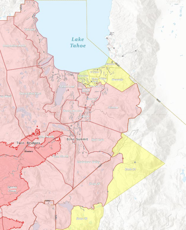
Tahoma
• The section from Emerald Bay north to the Placer county line in Tahoma, extending west to the border of Desolation Wilderness.
Fallen Leaf
• The area from Sawmill Road at Lake Tahoe Blvd. extending north to Pope Beach. Along the water’s edge to Eagle Point. From Eagle Point west, to Desolation Wilderness, across Emerald Bay.
Pioneer
• This is the area North of Elks Club along Highway 50 and the West side of Pioneer Trail, also including the streets of Hekpa, excluding the residences west of the airport, this segment includes all residences accessed from Jicarilla, Washoan, and Glen Eagles. This also includes the Golden Bear neighborhood, and the neighborhoods of Cold Creek Trail, High Meadows, and Marshall Trail.
Gardner Mountain
• Northwest of the South Lake Tahoe Airport and west of the Highway 50 / Lake Tahoe Blvd and Highway 89 intersection to include the South Lake Tahoe High School, Tahoe Verde and the streets accessed from 5th through 15th street south of Highway 89
Trimmer
• The area East of Pioneer Trail to the Alpine County Line stopping South of Heavenly Ski Resort, excluding all residence off of Pioneer Trail.
Evacuation Routes:
• For the areas of Fallen Leaf and Tahoma go North on Highway 89 towards Truckee.
• For all other areas, evacuate Eastbound on Highway 50 towards Nevada.
Evacuation Shelters:
• Truckee Veterans Hall
10214 High Street, Truckee, CA 96161
• A Red Cross Shelter is open for those evacuating from the area at the Douglas County Community Center, 1329 Waterloo Lane, Gardnerville, NV
NOTES:
Please go to: www.tinyurl.com/EDSOEVAC for an online evacuation map.
All previous evacuation orders and warnings remain in effect.
A mandatory evacuation order is defined as an immediate threat to life. This is a lawful order to leave now. The area is lawfully closed to public access.
An evacuation warning is defined as a potential threat to life and/or property. Those who require additional time to evacuate and those with pets and livestock should leave now.
For additional information, scan the QR code above or visit https://linktr.ee/imt6
Safety Message:
The public is reminded to stay vigilant on current fire conditions. Please continue to adhere to
road closures and any evacuation orders and warnings. A reminder to drive slowly and yield to
emergency personnel in the area. There will be smoke in the respective areas as firefighters
continue firefighting operations. If at any time you feel unsafe, please call 911.
www.readyforwildfire.org
###
Most of South Lake Tahoe Now Under Caldor Fire Evacuation Orders or Warnings added by News Desk on
View all posts by News Desk →
Are homes on pioneer trail jicarilla dr safe from fire
This is the best assessment tool for that. Not perfect and they are still doing inspections, but the best for now…
https://calfire-forestry.maps.arcgis.com/apps/webappviewer/index.html?id=366d1a3e25ce4a11a4c0846c3a337ce9&extent=-13464888.411%2C4646560.0626%2C-13348704.128%2C4707786.1223%2C102100